Commercial satellites go dark over Iran
Planet Labs and Vantor have restricted satellite imagery of the Iran war zone, raising questions about who controls the new era of open-source intelligence
THE LIFEBLOOD of modern accountability — commercial satellite imagery — is clotting. Over the past decade, firms like Planet Labs and Vantor (formerly Maxar) turned Earth observation into a public good, letting researchers, journalists, and armchair analysts pierce the fog of war with a few clicks. Now, as a widening conflict engulfs the Middle East, those images are vanishing from public view. The era of unprecedented transparency, it turns out, had an off switch all along.
The restrictions arrived swiftly. Planet Labs, which operates the world's largest fleet of Earth-imaging satellites, initially imposed a four-day delay on high-resolution imagery of the region after the Iran war began. That window quietly expanded to two weeks — a period covering the entire conflict to date — and broadened to include not just Gulf states but allied bases further afield and the whole of Iran. Vantor, for its part, has long withheld photographs of American installations and restricted imagery of Ukraine since 2022, but Planet had historically been the more permissive operator. Its stated rationale: balancing transparency against the risk that published images could be used for battle-damage assessment or targeting of allied forces. Jeffrey Lewis of the Middlebury Institute of International Studies in California put it plainly: the quality and quantity of commercial imagery is now genuinely useful for military planning, and nobody was prepared for a protracted conflict where a 48-hour delay would not suffice.
Fog of more
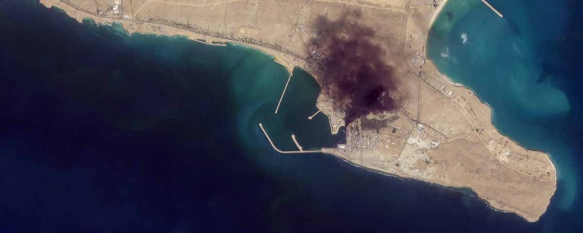
But the restrictions stretch well beyond operational security. Images of Iran itself — not just allied positions — have been curtailed, a decision that has hamstrung researchers trying to monitor the country's nuclear infrastructure. The Bushehr reactor, no longer subject to in-person IAEA inspections, is now effectively invisible to the open-source community as well. One industry insider attributes the Iranian coverage blackout to talk of American ground operations inside the country, including a potential raid to seize highly enriched uranium. Planet insists it acted independently, consulting intelligence and combat veterans. Yet the Trump administration has privately leaned on satellite companies through the National Reconnaissance Office, which builds America's spy satellites. In at least one instance last year, it demanded an analyst remove imagery showing American military movements related to Iran. Skeptics reckon the goal this time is not merely force protection but something broader: suppressing images that reveal American and allied losses. Early war footage showed precise Iranian strikes on radars, military bases, and oil refineries — imagery that contradicted Arab claims that production shutdowns had been voluntary.
This article is for Vector members. Start a 7-day free trial to keep reading.
Start your free trial